Saipan, Marianas February 8, 2017
Unfortunately, due to terrible weather, the lack of a breakwater at the port, a very narrow channel, and 11 foot waves in the harbor, our visit to this island was cancelled. I did hear rumors to this effect at breakfast, but paid no attention given the proliferation of rumors on the ship. However, sighting several freighters that seemed to be anchored should have been a clue. The rumor was confirmed by the Captain's announcement at about 8A.
I was disappointed, but the history is interesting. No pictures of course... I can tell you that there are two official languages here, neither of which is English. The first is Chamorroan, the other is from the Carolina (islands, that is) people who migrated here after the Spanish carted the Chamorros to Guam to "control" them.
Saipan is the second largest island of the Mariana Islands, but unlike Guam is a commonwealth of the United States. They have still not united with Guam due to a lingering resentment of their Japanese speaking inhabitants who came to Guam to interpret and did not treat their fellow Chamorros very well. At this point there is some talk of a union, but IMHO it will probably be at least another generation.
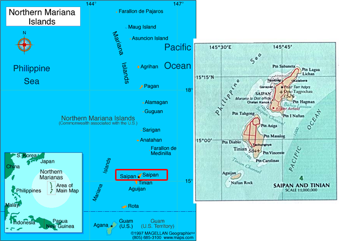
The 2010 United States Census, reported Saipan's population as 48,220. It is the second largest island in the Mariana Islands archipelago, after Guam. It is located about 120 mi (190 km) north of Guam and 5 nautical miles (9.3 km) northeast of Tinian, from which it is separated by the Saipan Channel. Saipan is about 12 miles long and 5.6 miles wide, with a land area of 44.55 square miles.
The western side of the island is lined with sandy beaches and an offshore coral reef which creates a large lagoon, but no breakwater. The eastern shore is composed primarily of rugged rocky cliffs and a reef.
The highest elevation on Saipan is a 1,560 foot limestone-covered mountain called Mount Tapochau. Unlike many of the mountains in the Mariana Islands, it is not an extinct volcano, but a limestone formation. About 2 miles north of Mount Tapochau towards Banzai Cliff is a ridge of hills. Mount Achugao which is most likely the remnant of a volcano.
History
(Abridged and edited from Wikipedia)
This is rather long, but this island has an interesting history, both pre and post World War II.
Archaeologists have found remnants of human settlements that date from 2000 B.C. Although sailors on many Spanish expeditions probably saw the island, it was 1668 before Spain officially occupied Saipan, naming it San Jose. Shortly afterwards it became a port of call for Spanish and occasional English, Dutch and French ships who used it as a supply station for food and water.
Not only European-introduced diseases, but conflicts over land ensued decimating the inhabitants. Forcible relocation of the remaining inhabitants to Guamn occurred in 1720 to allow the Spanish to better control and assimilate them and no doubt to take their land. The Spanish then developed Saipan into ranches for raising cattle and pigs, which were used to provision Spanish galleons. Further eroding the original inhabitants’ rights, in the early 19th century while the former Saipanese were imprisoned on Guam, many Carolinians from Satawal emigrated to Saipan resulting in more loss of land and rights for the former inhabitants.
The United States theoretically received Saipan in 1898 after the Spanish–American War. However, it was sold by Spain to the German Empire in 1899 (don’t ask me how they did this…). The island was administered by Germany as part of German New Guinea, but during the German period, there was no attempt to develop or settle the island, which remained under the control of its Spanish and mestizo landowners.
In 1914, during World War I, Japan captured the island. They were awarded formal control in 1918 by the League of Nations as a part of its mandated territory of Nanyo. Militarily and economically, Saipan was one of the most important islands in Nanyo and became the center of subsequent Japanese settlement. Immigration began in the 1920s by ethnic Japanese, Koreans, Taiwanese and Okinawans, who developed large-scale sugar plantations and sugar refineries. Under Japanese rule, there was extensive infrastructure development including the construction of port facilities, waterworks, power stations, paved roads and schools, along with entertainment facilities and Shinto shrines. By October 1943, Saipan had a civilian population of 29,348 Japanese settlers and 3,926 Chamorro and Caroline Islanders.
Japan considered Saipan as part of the last line of defenses for the Japanese homeland, and had strongly committed to defending it. The Japanese Army and Japanese Navy garrisoned Saipan heavily from the late 1930s, building numerous coastal artillery batteries, shore defenses, underground fortifications, and an airstrip. In mid-1944, nearly 30,000 troops were based on the island.
The Battle of Saipan from June 15th to July 9, 1944 was one of the major campaigns of World War II. The United States Marines and United States Army landed on the beaches of the southwestern side of the island, and spent more than three weeks in heavy fighting to secure the island. The battle cost the Americans 3,426 killed and 10,364 wounded, whereas of the estimated 30,000 Japanese defenders, only 921 were taken prisoner. Weapons and the tactics of close quarter fighting also resulted in high civilian casualties. Some 20,000 Japanese civilians perished during the battle, including over 1,000 who committed suicide by jumping from "Suicide Cliff" or "Banzai Cliff" rather than be taken prisoner. After the war, nearly all of the surviving Japanese settlers were repatriated to Japan.
After the end of World War II, Saipan became part of the Trust Territory of the Pacific Islands, administered by the United States. Since 1978, the island has been a municipality of the Commonwealth of the Northern Mariana Islands (CNMI). The military presence began to be replaced by tourism in the 1990s, but it still plays an important role in the local economy.
Post World War II
After WW II the USA agreed that the CNMI would be exempted from certain federal laws, including some concerning labor and immigration. The result was the importation of cheap foreign contract labor, mostly from China, that drove the growth of hotels and tourism and started garment manufacturing. These factories could label clothing “made in the USA,” and avoid import tariffs. Workers had their passports confiscated, had absolutely no rights, worked 12 hour shifts seven days a week, had poor living conditions, and were virtual prisoners.
As these practices became more widely known in the continental U.S., there was pressure on Congress to stop it which was vigourously fought by the beneficiaries. From 1995 to 2001 Jack Abramoff and his law firm were paid at least $6.7 million by the CNMI to prevent any congressional action prohibiting this slave labor. Later lobbying efforts involved mailings from a Ralph Reed marketing company and bribery of Roger Stillwell, a Department of the Interior official who in 2006 pleaded guilty to accepting gifts from Abramoff. After a protracted battle in Congress and despite strong lobbying effort by Saipan’s Governor Fitial to stop it, President Bush signed PL 110-229 into law in May 2008. Federal takeover of immigration began November 28, 2009.
U.S. businesses that took advantage of the prior scheme were Gap, Levi Strauss, Van-Heusen, Abercrombie & Fitch, Ralph Lauren, Lord & Taylor, Tommy Hilfinger, and Walmart. Once the U.S. took control of immigration the practice was halted and the garment factories, deprived of cheap labor, closed.
Although there is an annual rainfall of 80 to 100 inches, the government run local water utility is unable to deliver 24-hour portable water to all areas. As a result, several large hotels desalinate ocean water to provide fresh water for their customers. In addition, many homes and small businesses augment the sporadic and sometimes brackish water provided by the utility with rainwater collected and stored in cisterns. Most locals buy drinking water from water distributors and use tap water only for bathing or washing because it has a strong sulfur taste.