Guam February 7, 2017
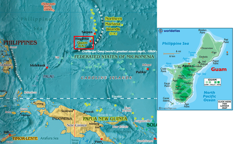
Overall map of Pacific Islands
Guam, formally the Territory of Guam, is an unincorporated, organized territory of the United States. Located in the western Pacific Ocean, it has an established civilian government. It has an area of 210 square miles, a length of 30 miles and is 2 to 12 miles wide. It is the largest and southernmost of the Mariana Island Group, and the largest island in Micronesia.. In 2015, 161,785 people resided on Guam. Guamanians are American citizens by birth.
Brief (very) History of Guam
(Abridged and edited from the Wikipedia Guam entry with additions from our guide)
The Chamorros, Guam's indigenous people, settled the island approximately 4,000 years ago. They are believed to be descendants of Austronesian people originating from Southeast Asia, probably Taiwan, about 2000 BC. Their ancient society had four classes: chamorri (chiefs), matua (upper class), achaot (middle class), and mana'chang (lower class). The matua lived in the coastal villages, which meant they had the best access to fishing grounds, whereas the mana'chang were located in the interior of the island. Matua and mana'chang rarely communicated with each other, and matua often used the achaot as intermediaries. There were also "makåhna" (similar to shamans), skilled in healing and medicine. Belief in spirits of ancient Chamorros called "Taotao mo'na" still persists as a remnant of pre-European culture. Their society was organized along matrilineal clans.
From information that a friend who was Dean of the Health Sciences at the University of Guam shared, this caste system is not exactly extinct in Guam and many of the other islands of the Pacific. According to her it makes it difficult to disseminate knowledge to various groups who do not want to interact with the other “classes.” This same type of society was originally in the Hawaiian Islands.
The first European to visit Guam was the Portuguese explorer Ferdinand Magellan sailing for Spain who arrived there in 1521. Between the 1500s and the 1700s, Guam was an important stopover for the Spanish Manila Galleons. This of course led to piracy with the result that several forts were built on the hills overlooking the harbor. Like all “new world” places conquered by a European Country disease decimated the Chamorro population which went from 50,000 to less than 5,000.
The Spanish occupation was hardly peaceful. There was intermittent warfare from 1670 until 1695. Captain Juan de Santiago started a campaign to pacify the island, which was continued by the successive commanders of the Spanish forces. Captain Damian de Esplana, who arrived in 1674, ordered the arrest of rebels who attacked the population of certain towns leading to the destruction of many villages. Eventually the Spanish took control and ordered the construction of schools, roads and other infrastructure. After 1767 when Charles III of Spain expelled the Jesuits, a governor arrived who brought agricultural reforms, including making land available to the islanders for cultivation and encouraging the development of cattle raising. He also directed the importation of deer and water buffalos from Manila and donkeys and mules from Acapulco. The first Guam militia was established under him.
When Mexico became independent following the Napoleonic Era, Guam’s economic dependence shifted from Mexico to the Philippines. There is to this day a positive relationship with the Philippines. In 1898 the U.S. was ceded Guam under the Treaty of Paris which ended the Spanish-American War. In 1903 the Commercial Pacific Cable Company built a telegraph/telephone station there and in the 1930s Pan American Airways established a seaplane base on the island for its San Francisco-Manila-Hong Kong route. Currently Guam is a hub city for United Airlines.
On December 7, 1941, hours after the attack on Pearl Harbor, Guam was attacked by the Japanese. Fearing just this, the inhabitants had formed a militia of sorts and resisted the Japanese for three weeks. Japan occupied the island for 30 months until it was freed by the Americans. During the occupation, Guamanians were subjected to culture alignment, forced labor, beheadings, rape, and torture. They were also forced to build more fortifications to repel future U.S. attacks.
The Northern Mariana Islands especially Saipan had become a Japanese protectorate before the war and the Japanese brought in Saipaneses Chamorros to serve as interpreters and other capacities for the occupying Japanese. The Guamanian Chamorros were treated as an occupied enemy by the Japanese military. One of our group had an uncle who was a civilian on the island when the Japanese invaded. He was taken a prisoner of war, although a civilian one and taken to a prisoner of war camp for civilians in Nagasaki. He was there when the atom bomb was dropped.
There was much resentment of the Guamanian Chamorros about the use of the Japanese speaking Chamorros to aid the ocupiers. Guam's Chamorros believed their northern brethren should have been more compassionate towards them, whereas having been essentially Japanese for over 30 years, they were loyal to Japan. These two groups are just now working towards overcoming this animosity.
On July 21, 1944 the U.S. invaded and recaptured Guam, a day that is now commemorated annually as Liberation Day. However, it was a bloody three-week war. After World War II, the Guam Organic Act of 1950 established Guam as an unincorporated organized territory of the United States. It provided for the structure of the island's civilian government, and granted the people U.S. citizenship. Before 1968 the Governor of Guam was federally appointed, a practice changed that year when Congress passed the Guam Elective Governor Act which allowed the islander’s to elect their own Governor.
Because Guam is not a U.S. state, U.S. citizens residing on Guam are not allowed to vote for president and their congressional representative is a non-voting member. They do, however, get to vote for party delegates in presidential primaries.
Visit to Guam
Due to customs taking their sweet time, we were two hours late getting off the ship. To make up for this the captain added an extra two hours to our stay, but our tour folk apparently wanted to stop at 4:30 no matter what and they did, which was unfortunate.
Our guide did share some interesting facts. 43% of the 260,000 inhabitants are Chamorros. Much of the island was decimated in World War II and much of the rebuilding was contributed by the Phillipines. Today the only vestiges of the war are the memorials which we visited. 1/3rd of the island’s population is made up of Naval and Air Force Personnel. The Navy has a large base in the south of the island (the hilly part which is of volcanic origin and the Air Force in the north (which is relatively flat and largely limestone). There are coral reefs surrounding that part of the island. Although Guam at one time was self-sufficient they now import 90% of their supplies, hence a large container port. They are working towards less dependence on outside sources.
The economy is military and tourism. They have beautiful beaches with one that, according to our guide, is like Waikiki. The tourists are mostly Japanese, Korean, and now an increasing number of Chinese. The latter have invested heavily in the island.
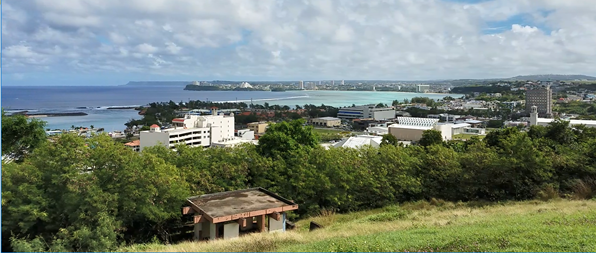
The road to our first stop, Fort Santa Agueda, afforded us views of the blue ocean as well as going through what was jungle. The “fort” is on a hill and features gorgeous views of the harbor, the reef (a place where the waves broke), and much of the city. One can easily imagine the Japanese firing down on our troops in July 1944.
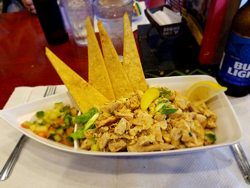
Our late start made lunch at Chamorro Village the next stop. I took the opportunity to sample the national dish, Kanguelan. You can get it with beef, fish, shrimp or chicken. I choose the latter. It was slightly spicy, but 100% delicious. Yes, I had to have a beer with it…
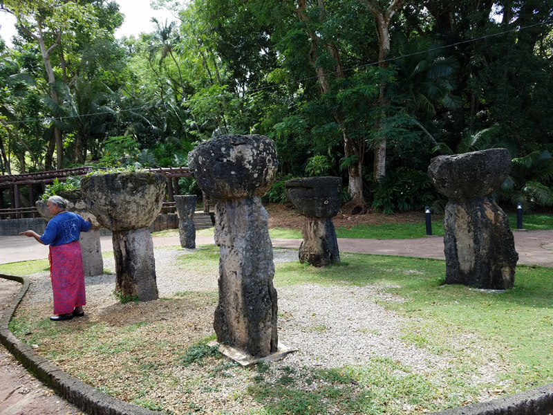
After lunch we visited Latte Park. No, it is not a park for drinking lattes, but a park where they have relocated some of these stone edifices known as lattes. They are constructed of limestone, with a capstone of tasa. In the pre-European society, roughly from 900AD to 1700AD lattes were the foundation for their thatched huts essentially meaning these huts were on “stilts.” The height of your lattes indicated your position in the community. The chief had the tallest lattes and it descended from there.
Today all houses are of concrete or one cannot get insurance. Typhoons sweep over the island about once a decade. The guide was very upbeat about this, saying that they are needed to clean the trees of dead or dying branches. She seemed to think that they were due for another, pointing out the thickness of the tree branches. From stories my Guam friend told me, everything is pretty secure against the typhons, and there is little real damage. Of course one loses power, but the tall buildings in the main city remain largely intact.
The War in the Pacific National Park had many exhibits presenting stories of the resistance of the local guard to the Japanese invasion, stories from some of the survivors of the occupation, and a large animated map with narration of the 1944 battle. The narration is available in both English and Japanese. I wonder how the Japanese feel seeing these exhibits, and they do visit.
As it became apparent to the Japanese that the allies would invade, they herded the Chamorros into concentration camps in the center of the island. Although the conditions were horrible there, it did serve to protect them from the attacks and counter attacks, thus they were not shelled by either side.
One exhibit featured songs that the locals made up lamenting the occupation. One was “Uncle Sam Won’t You Please Come Back.” Of course it was forbidden to utter these words, let alone sing them, but they did persist.
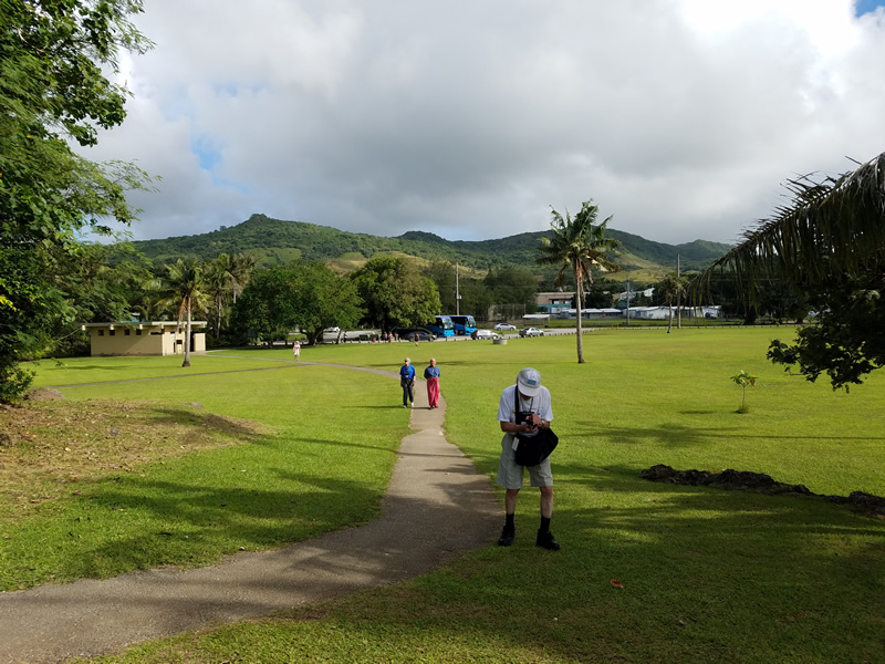
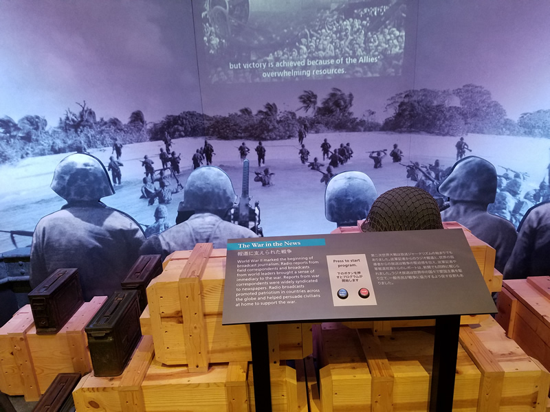
I took the following picture from the War Memorial because it depicts the allied troops as they took the beach. The smoke in the background is Japanese firing from the hills. Ignore the video!
The War in the Pacific Memorial Park is another reminder of the invasion. The location is a spot where the Japanese were able to fire at the allies. Today it is a peaceful, beautiful spot with some pillboxes as a reminder that it was not always so peaceful. At this site they fly 3 flags, the U.S. in the middle, the Japanese on one side and the Guam flag on the other. Including the Japanese flag has engendered controversy, but the National Park Service has remained firm in keeping all flags flying. One part of the park leads down to the ocean and I am happy to say that I joined many of my colleagues, in removing my shoes and socks, and wading into the ocean. It was very warm!
The photo is looking towards the hills that were well fortified.